A topographic survey, also referred to as a land, terrain or topo survey, is a type of survey that maps the boundaries, features, and levels of a site. Topographic surveys are a key component of the design process for a site and should be completed prior to detailed design work.
What are topographic surveys used for?
As well as professionals, such as architects, civil engineers, and planners, using topographic surveys to make informed decisions on design and project management, topographic surveys are also used as a legal document to define boundaries of a property.
What is likely to be surveyed in a topographical survey?
Depending on the requirements of a project, the surveyed elements will vary. Typical elements include the following:
- Area boundary lines
- Buildings & structures
- Features adjacent to the site
- Trees, bushes & vegetation positions
- Ground heights, contours & surfaces
What Equipment is Used for Topographic Survey?
To produce precise measurements of a site, a wide range of equipment is used. Accurate GPS equipment is used to survey the area, producing fixed points of an area of land.
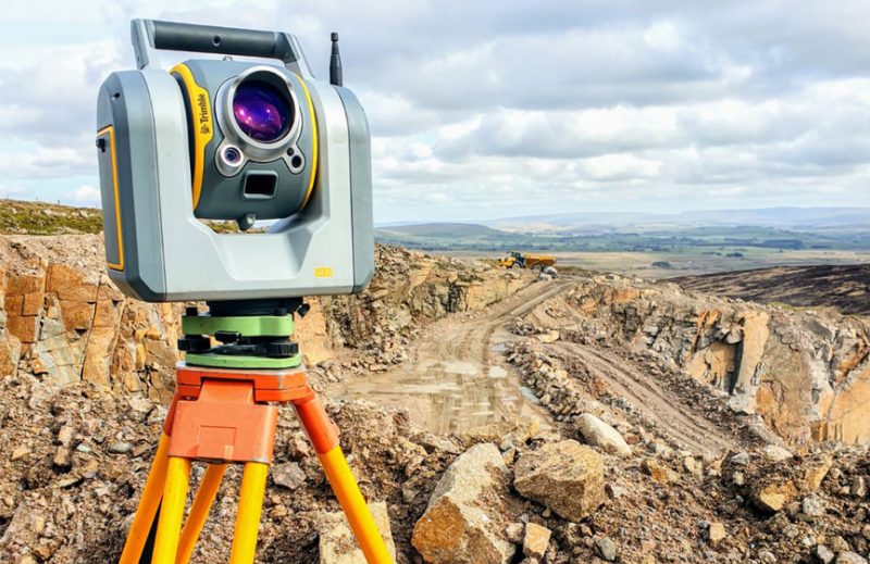
Our surveyors use Trimble S6 and S5 Robotic Total Stations, and Trimble R10 & R8 GPS receivers to carry out our surveys. Using these instruments allows our team to capture reflectorless measurements, which is particularly useful for producing streetscapes of adjacent building elevations. Our surveyors also utilise UAV drone technology for producing topographic surveys of larger, less accessible sites. Find out more about how drones can be used for topographic surveys here.
What are the benefits of topographic surveys?
Topographic surveys are highly beneficial for a number of projects, with one of the main benefits being that they aid with planning and decision-making. A topographic survey provides accurate land measurements and gives a clear indication of the arrangements of an existing site, which can be used to make decisions on the planning of new buildings, re-positioning of existing boundaries, and the design of drainage systems.
Another benefit of topographic surveys is that they can save a significant amount of project time and reduce the risk of costly errors occurring, as all decision making throughout the project has been informed by accurate data from the topographic survey.
How long does a topographic survey take?
The duration of a topo survey is dependent on the size and complexity of the proposed site and project.
After the site has been surveyed, it typically takes a few days for findings to be drawn up and sent over. Depending on the detail required for a project, data will be presented in either a simple 2D plan, or a 3D AutoCAD drawing, when a greater level of detail is needed.
How Landform Surveys Can Help You
At Landform Surveys, we have years of experience in carrying out topographic surveys. Get in touch with our surveyors today to find out how your project could benefit from a topographic survey and discuss your options.
