In this article, we’ll outline all the different ways monitoring surveys can be completed, and discuss the best equipment to use for each.
Monitoring surveys measure how much a structure or building has moved over time. They are essential as they can prevent potential injuries or even loss of life from structural collapses.
But, how are they carried out? In this article, we’ll outline all the different ways monitoring surveys can be completed and discuss the best equipment to use for each.
The Procedure of Monitoring Surveys
There are four different ways monitoring surveys can be carried out, which are:
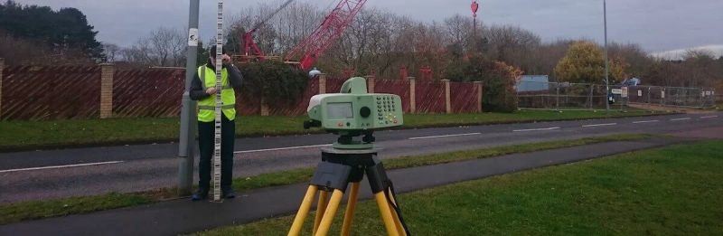
Fixed Position Monitoring
The first step in this process is setting up the local survey control network and monitoring targets. These targets, which are usually reflective stickers or survey prisms, should be glued or screwed into place at set points on the structure. The local survey control network is also made up of reflective target stickers or survey prisms, which are placed away from the structure.
The survey is then completed using a total station. Total Stations are very accurate optical tools that are used to find angles and distances. Usually, they are set up on tripods so that an operator can look through the lens and see the survey points.
Laser Scanning
In this process, a laser is used to scan the structure. By comparing scans taken over time, a “heat map” can be made that shows any areas that have moved.
This is better than fixed point positioning because it looks at the whole structure instead of just a few points.
Tilt Sensor Monitoring
With this method, tilt sensors are attached to the wall of a building involved in the monitoring process. These sensors accurately measure a structure’s angles and send this data to a central hub at regular intervals.
Crack Monitoring
The first way you can monitor cracks is by using crack gauges. These are fixed on both sides of a crack, so the gauge can observe the movement of the crack as it opens and closes.
The second way is using monitoring studs. A stud is glued to both sides of the crack. Then, a calliper should be used to record the distance between them. Then, the distance is periodically checked. Any changes detected will indicate if the crack has gotten wider or closed up.
Monitoring Surveys with Landform
We collect and accurately measure data using precise levels, accurate to 1/10th of a millimetre as well as movement gauges, reflectorless total stations and micrometres.
We can offer you an exceptional service tailored to your needs, whether that be in real time or over long term.
Contact us to see how we can help.
