Here at Landform Surveys we like to keep at the forefront of modern surveying technology in order to streamline and optimise our operations. Recently we purchased a Trimble SX10, which we added to our already extensive fleet of surveying instruments.
Trimble’s patented technology has long since been the industry leader for both land and building surveying. The SX10 proves itself a remarkably capable instrument in the field – it enables the capture of both high-accuracy measurements critical for traditional survey projects, and rich point cloud data at 26,000 points per second with a range of up to 600 metres.
What does this mean for our surveyors?
Well, they’ll be able to use 3D scanning as part of everyday workflows, which dramatically increases productivity for topographic surveys, roadway and corridor surveys, volumetric surveys and infrastructure as-builts.
What spec does the SX10 feature?
This highly capable instrument combines surveying, imaging, and high-speed 3D scanning in one revolutionary solution.
It also features:
- Trimble’s own high accuracy lightning 3DM technology. This provides scanning range up to 600m and captures the smallest spot in the industry – a mere 14mm at 100m range.
- Again, original Trimble technology shines – the VISION™ software feature allows for fast and easy capture of site imagery, at incredibly high resolutions.
- The SX10 integrates effortlessly with familiar workflow tools like Trimble Access and Trimble Business Centre software.
How is the SX10 better than its older equivalents?
With the combined versatility of simultaneous 3D scanning and surveying, the SX10 removes the need for surveyors to carry a dedicated 3D scanner.
This will save us significant operational costs and allow us to dedicate our existing TX8 scanner to more specialised point cloud tasks, and as-built measured surveys.
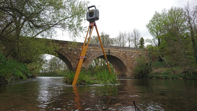
Recently, we used the SX10 to survey a bridge in Northumberland as part of a project involving both a conventional topographic survey and a full elevation survey.
Thanks to the SX10’s incredible versatility, both tasks were completed in one trip. We have Steve Cannon at Korec to thank for sourcing the instrument so quickly for us – it’s made a significant improvement to our operations!
