The UK's road network is highly congested. Still, around 4 million excavations take place on UK roads each year with the aim of installing, replacing or repairing buried utility pipes and cables. If contractors don't know the location of the utilities, huge problems arise.
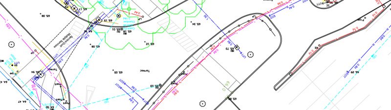
Underground utility surveys take place regularly to consistently update or create records pertaining to the location of buried utilities. They are vital to ensuring that work can take place safely, as well as quickly – a must on the UK’s busy and cramped road networks.
However, underground utility surveys don’t come without their own set of challenges.
What are the challenges faced during an underground utility survey?
The main challenge underground utility surveyors face is maintaining accuracy across their work. There are repercussions for providing construction workers with inaccurate utility location data, meaning that the knock-on effects of a wrongly-surveyed pipe or wire are enormous.
Geoff Zeiss, Principal at Between the Poles – a thought leadership consulting firm – reports that in the US it is estimated that an underground utility is hit every minute. Conflicts of location regarding underground utilities are the primary cause for project delays during construction projects, especially those taking place on public roads.
The economic cost goes much further than a direct strike on a utility – factor in the cost of disruption to traffic, schedule delays, and lengthened contracts for workers, and the economic impact is significantly higher.
When working on projects involving underground utilities, there is also the risk of injury for utility owners, road users, and contractors due to previously inaccurate location surveys. Underground utility surveying is used to rectify these mistakes and provide construction project managers with the right mapping data necessary to minimise such economic repercussions, but the surveying process itself can be costly and run into just as many of the challenges mentioned above.
So surveyors must be vigilant in their mapping of underground utilities, or risk costing their own sector – as well as a multitude of others – a wealth of time and money that could have been saved if only they’d championed accuracy down to the millimetre.
How can we maintain accuracy in underground utility surveys?
British Standards Institution (BSI) PAS 128 is the current specification for underground utility detection, verification and location. A collaboration between BSI and the Institution of Civil Engineers (ICE) resulted in the PAS 128 standard which requires accurate, quality information to be recorded to a consistent standard with regards to the location of underground utilities. This removes the element of uncertainty, interpretation and resultant variable risk when end users are referring to utility survey reports.
PAS128 defines four types of survey:
- desktop utility records search (survey type D) –
where underground utilities are identified through the collation and analysis of existing paper/online utility records;
- site reconnaissance (survey type C) – where existing records are supported and validated by the visual inspection of physical evidence observed during a site visit;
- detection (survey type B) – where underground utilities are detected and located by geophysical techniques;
- verification (survey type A) – where underground utilities are observed and located at a manhole or inspection chamber, or are excavated and exposed.
Only last year, the new PAS 256 standard “Buried services – Collection, recording and sharing of location information data” was released in order to provide a modern and more accurate approach to capturing and recording information. The PAS (Publicly Available Specification) 256 Standard is endorsed by the Institute of Civil Engineers (ICE), British Standards Institute (BSI), and Infrastructure UK in HM Treasury.
It sets out a consistent and accessible data protocol to enable “effective recording and sharing of the location, state, and nature of buried assets, and recommends how existing asset records should be updated, recorded and collated.”
According to the ICE website, the PAS 256 also covers:
- “the gathering of geospatial data using absolute or relative accuracy, plus associated evidence (such as photographic evidence);
- measurable deviations from straight-line installations, where appropriate;
- the absolute depth of the asset;
- the number of days to record and make available the asset data, once collected; and
- the sharing of collected asset data.”
Surveyors can abide by these standards in order to better streamline the data collection and reporting approach, which in turn shortens the time spent working on the UK’s already congested roads.
At Landform Surveys, we use radio detection and ground-penetrating radar techniques to locate underground utilities. The services are mapped accurately, and results supplied as a utility survey in CAD format. Speak to us today.
