In recent years the surveying industry has seen an influx of technological advancement. One of the most notable is 3D laser scanning technology, which we use for some of our surveys. It offers contractors and surveyors alike the opportunity to make jobs more efficient and accurate and keeps the industry moving in the right direction.
In this blog, we explain how 3D laser scanning works and how it benefits a survey.
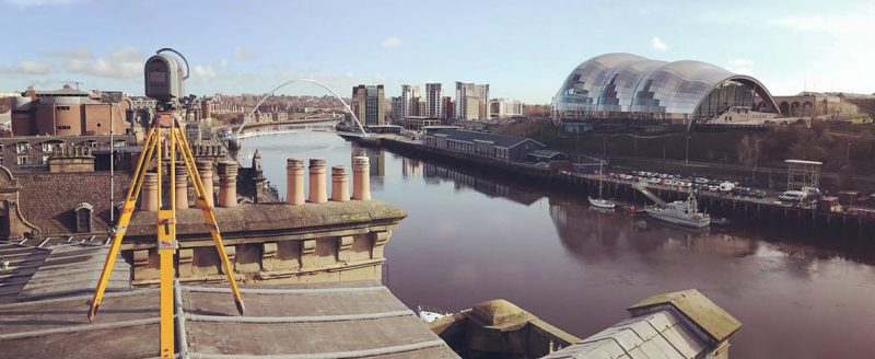
How does it work?
A 3D laser scanner emits beams of laser lights across the area you want to scan. It can measure the distance based on how long it takes the beams of light to return, as well as accurately calculate 3D locations at high speeds.
Essentially, these scanners are able to create ‘point clouds’ of data from the surface of an object, feature, or area. Each ‘point’ can be mapped accurately in 3D rendering software, offering surveyors a completely 3D digital map that is accurate in terms of both dimensions and spatial relationships.
How can I use it for my survey?
They can be used for numerous surveying applications – wherever the survey requires an accurate, 3D point cloud, 3D laser scanning may be a technological candidate. The point clouds it creates can be viewed in multi-hued colour or true colour on a digital camera (based on signal intensity return).
Plus, 3D laser scanning returns rapid and accurate results for areas which may be geometrically complex, or inaccessible. It is commonly used in civil engineering projects, particularly those dealing with infrastructure, and is the main technology used to perform accurate elevation surveys.
What are the benefits?
One of the main benefits is the speed at which it can perform highly accurate scans. Plus, with value-added datasets, the surveyor is able to check the data being collected in real-time (i.e. in the field) and correct any issues before they return to the office.
3D laser scanning also offers major cost savings to the surveyor. Due to the increased levels of accuracy, there is often little need for fit-ups or re-working. This technology is also entirely reflectorless, reducing the need for access platforms, and increasing the levels of safety that workers are able to enjoy.
Looking for a surveying company confident in its use of 3D laser scanning technology? We can help. Get in touch with a member of the Landform Surveys team today to discuss your survey.
