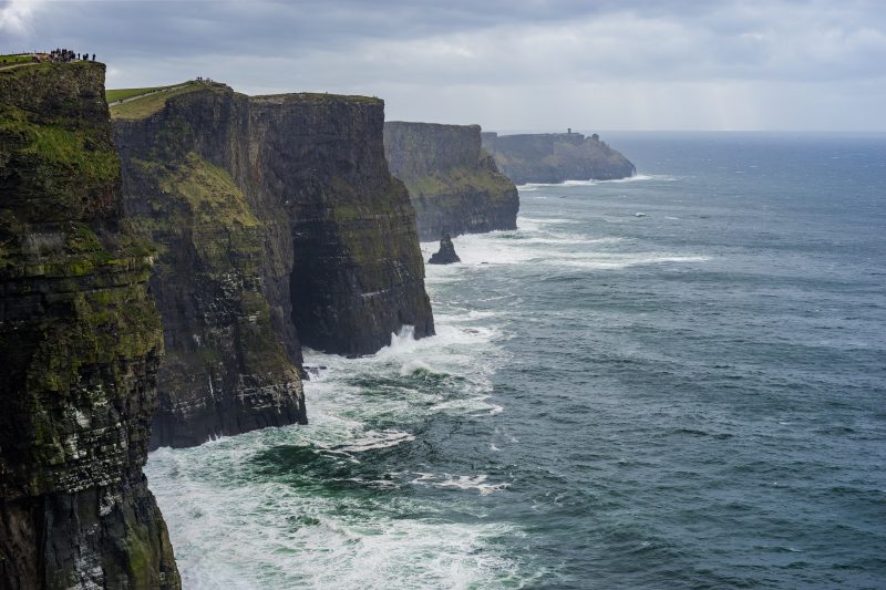
As climate change continues to champion a rise in sea levels, the English coast is regularly experiencing batterings in the form of floods and coastal erosion. Coastal erosion is occurring along 17% of the UK coastline - this is 30% of England's coastline, 23% of Wales', 20% of Northern Ireland's, and 12% of Scotland's.
The British Geological Survey reports that across England and Wales alone, 9000 commercial properties and 5000 hectares of farmland are at risk of damage from coastal erosion.
The natural response to coastal erosion is to migrate landward – this means residents of coastal settlements are being forced to abandon homes and accept the risk of flooding and damage to property, as well as the loss of surrounding coastal features.
How is coastal erosion and protection managed in the UK?
The current approach to coastal protection in the UK focuses on establishing a risk level and then acting accordingly. The defence tactics are divided into four distinct categories referred to as Strategic Coastal Defence Options. They are as follows:
- Do nothing – here, no coastal defences are put in place, and the coast is not monitored
- Hold the line – maintain the existing protection line, and potentially adjust the protection standard
- Advance the line – advance the existing protection line (often a result of a survey on a ‘hold the line’ area)
- Retreat the line – also referred to as ‘managed realignment’, this involves retreating the existing protection line
How is coastal erosion monitored?
To ensure that these efforts are accurate and constantly managed, the British Geological Survey (BGS) uses terrestrial laser (LiDAR) systems paired with GPS to execute monitoring surveys along the UK coastline.
For example, cliff erosion and landslides in the South and East coasts of England are monitored using the aforementioned technology in order to give coastal management schemes a better understanding of the complex processes taking place.
LiDAR technology has been exceptionally useful in monitoring the quick changes in coastal topography that satellite data fails to pick up in time to inform executive coastal protection decisions. However, even this state of the art surveying technology has its downsides.
You’ll often find LiDAR technology situated on soft, sandy beaches as it operates a scan. These can take upwards of thirty minutes, and errors can be incurred as the tripods slip into the sand or move slightly down the beach as a result of wind/rain.
How can UAV technology (drones) be used for coastal surveys?
Using LiDAR scanning technology to monitor coastal erosion can be expensive, labour-intensive, and time-consuming. However, all is not lost! Surveyors are looking to an emerging field of tech to survey more effectively, efficiently, and cost-effectively.
Using Unmanned Aerial Vehicle (UAV) technology, or drones, is quickly becoming the go-to surveying technique for monitoring coastal erosion in the UK. They can go where LiDAR systems can’t – many coastally eroded areas in the UK are particularly dangerous to access on foot, an obstacle which drones have no problem in overcoming.
Even in harsh weather conditions, specially designed drone surveys can fly over the coast, taking high-quality images and video footage of the constantly changing coastline.
However, because drones are moving objects, they are subject to data errors based on their proximity from the ground, and their constant motion. Coastal surveyors use GPS correction technology in order to ensure that the data they gather is as accurate as possible.
How accurate is UAV surveying in monitoring coastal erosion?
To achieve high spatial accuracies, there are three ways a surveyor can use UAV technology:
- They can correct position information using post-processing kinematic (PPK) systems
- They can combine image data with Ground Control Points (GCPs)
- They can correct position information by using real-time kinematic (RTK) systems
Ground Control Points (GCPs) are points on the surface of the earth of a known location. When geospatial data processing takes place, GCPs are tied to georeferenced images in order to pinpoint real-world locations. GCP-enabled drones are able to obtain extremely precise survey data; often down to a sub-centimetre level.
However, the groundwork involved in setting up a GCP-based survey is extensive and is not suitable for monitoring constantly changing (and sometimes extremely dangerous) expanses of coastline.
Most coastal surveyors will choose PPK systems to power the data collection element of their UAV survey.
PPK systems, such as the ones used in your mobile phone’s GPS system, do not require a real-time data link with a fixed reference station. This means that in the event of sudden bad weather, or loss of signal due to proximity from the base station, the drone will still be able to capture and store data.
PPK systems do this by storing “backup” data, meaning the drones using these systems can be slightly bulkier, but it’s worth the weight for the accurate data collection, and the defensive measures that are subsequently put in place to protect the UK coastline.
The future of UAV surveying
Monitoring the UK coastline using drones is already becoming a reality. Companies in the North East of England are particularly interested in developing technology that is capable of withstanding particularly harsh wind and rain, whilst still maintaining stellar levels of accuracy in data capture.
The data collected by coastal drones is invaluable and will help the Environment Agency best allocate funds to areas most at risk.
UAV surveying from Landform Surveys
At Landform, we believe that integrating new technologies into our existing workflow helps us deliver an even better service to our clients.
If you think your land survey would benefit from drone inclusion, or you want to know more about how we use drones to optimise the collection of your data, get in touch with a member of our team today.
