When people see surveyors out in the field they may not think it is that difficult, that it is a bunch of people standing behind a theodolite and going home at the end of the day. However, it’s the experienced professionals that make something complicated seem easy but it takes a lot of hard work and training to get to that point. Surveying is a science that has been shaping our world for hundreds of years in its modern form.
Our world is based on measurement and mathematics, and surveying brings them to life. At its core, most surveys are the basis for measuring the natural and built environment and then further mapping and modeling accompanies that. While on their own, the individual data points are isolated and not all that helpful, when used together they create a bigger picture.
Surveying can be used for several different applications. The data that surveyors collect is used by architects, engineers of all types, construction managers and foreman, quarry managers, accountants, economists, estate agents, planning agencies, government officials, councils, homeowners and landlords, and many other people.
Architects and engineers depend on the measurements that come from surveys such as a topographic survey or 3D laser scanning survey so that they know what they are working with. This plays a part in the larger world as people need buildings and their surroundings to work, live and enjoy their leisure time in.
The data gathered from surveying helps establish planning and design and provides data that can be used to determine the best course of action. These can be as diverse as deciding the routes of major infrastructure projects, to planning a simple house extension.
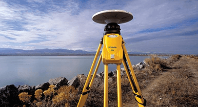
Comparing data over time can help map coastlines, erosion, and climate change. It is also important for the conservation of land, buildings, and the safety and maintenance of buildings and quarries.
Bathymetric surveys can also reveal what is beneath water bodies, better informing project managers before they begin a development near water.
Land and buildings are our resources and surveying help to use them in the best way possible. So with surveying being the basis of so many things, where would we be without it?
If you have a building or property that would benefit from a survey, get in touch.
