The earth is constantly evolving due to geological processes like erosion, weathering, and plate tectonics. Though these processes are natural, they threaten to disrupt the lives of people living in high-activity zones, such as those by the sea; near land fissures; or within the boundaries of an active volcanic site.
Land displacement – landslides in particular – occur on nearly every continent on earth. Because they’re so common, it’s important that geologists and surveyors work together to monitor the risks they pose, as well as collect important data on the way land is constantly changing.
Why is land displacement monitoring important?
Typically, monitoring is required to determine the magnitude, extent, and style of landslide movement – this information can be used to enhance ongoing studies and provide valuable data on individual land displacement sites.
Data collected from the monitoring of landslides can be crucial in informing emergency risk assessments, especially during periods of adverse weather. Information on direction of movement and erosion rate is supremely useful in design projects, as well as in the planning of remedial or mitigation works.
What types of land displacement are there?
Different types of land can be either more or less prone to specific types of land displacement. In the UK, rotational landslides (also known as rotational slips) are common due to the geological nature and climate, especially across the midsection of England.
A common analogy used to describe how a translational landslide occurs is the process by which sand is poured from the back of a tipper truck – as the angle of the sand slope steepens, gravity forces the top layer of material to slide towards the ground. In the same way, over-saturated ground can become too heavy for the base material beneath it, meaning it succumbs to gravity and the slope fails.
In areas where a maritime climate prevails such as Wales, flows can occur. This type of landslide happens when surface material becomes so saturated that it begins to behave like a liquid and breaks away from the base layer.
Conversely, a topple will occur when material at the bottom of a slope is eroded so drastically that the material above it becomes top-heavy and breaks away. This type of erosion is commonly found along cliffs, where waves erode base material, causing eventual collapse.
How do surveyors monitor land displacement?
For many years, there was no way to measure the impact of a landslide. Even though the relationship between heavy rainfall and increased risk of landslide was known as early as the 1700s, there was no effective monitoring methodology in use at the time.
These days, geologists and surveyors work together to monitor the behaviour of various land displacement occurrences using modern technology and remote data capture systems.
Depending on the intended survey outcome, the technology chosen to monitor a landslide will differ. If the intended outcome is simply to identify a landslide site, surveyors can aggregate satellite data from a previous point in time using a Geographic Information System (GIS).
This type of data retrieval is accurate and reliable – satellites are constantly monitoring the earth from all angles, meaning that determining a landslide site is as easy as playing spot the difference. In recent years, satellite data capture has advanced to the point that it can detect movement down to centimetre level resolutions.
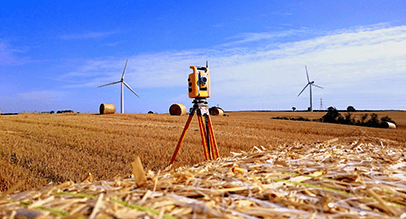
How do surveyors use remote and automated monitoring technology?
In areas prone to landslides or heavy rainfall, a surveyor will install soil and hydrological monitoring instrumentation, communications equipment, and solar power. Typically, the data-collection system will be designed to collect data in real-time, as well as deliver that data to an off-site system where it can be viewed and analysed.
Depending on the sensor being used, the system should read and record data every few minutes or second.
Monitoring remotely using sharply calibrated instruments provides surveyors with better data on how rainfall causes landslides, for example. This data can also be used to work out how water moves down a hillside prior to a landslide, which helps surveyors and geological scientists predict when one might occur.
Get in touch!
Interested in land displacement monitoring or risk assessments? Get in touch with Landform Surveys today.
